The Ghost Rider "Ride-along"
Below we review how the Ghost Rider "Ride-along" came about, how we did it and how you can join in on the journey!


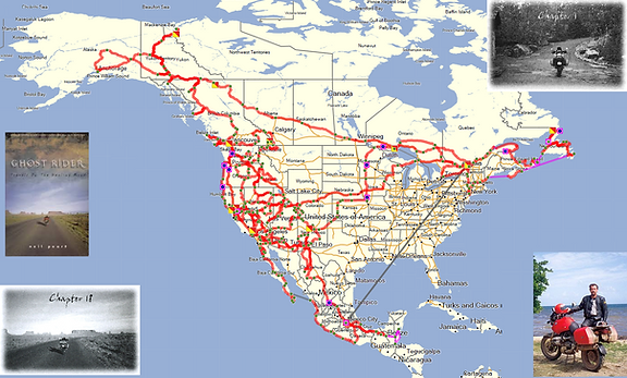
LONG before we started Sunlight on Chrome, we got a little bee in our bonnet "Wouldn't it be great if someone mapped out the route NEP took on his Ghost Rider travels?"
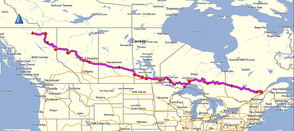
Having checked the "net" and only coming up with one partial map (shown/linked below)...
we decided to re-read Ghost Rider, this time just scanning the pages for venues, routes, towns, etc. that he mentioned. Each was then marked in red pen.
We got halfway through, but then life got busy, family/work crowded in and, well, the idea was pushed to the side. This was probably somewhere in 2018.
In January of 2023, after having decided to coordinate another SoC fundraiser in NEP's honor (SoC3, for July 2023), it occurred to us that finishing this routing project might be a good use of time, as others in the SoC universe might find it interesting/fun to see the roads (and sights!) that NEP took in on that epic trip! We broke out the book again and got to work marking venues! We finished this up in ~1 month, but then the REAL WORK began!
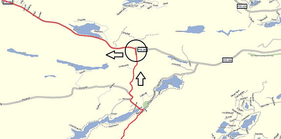
Having been an avid motorcyclist myself for a ~18 years (due to reading Ghost Rider that first time!), I was very familiar with various trip routing devices and software. In particular, I use Garmin systems (and named my unit Demwit, in keeping with NEP and his riding partner's units, Dufos and Dingus). The Garmin software I use these days is called Basecamp (older versions: Mapsource) and allows you to enter in waypoints (marks on the map) and connect them all with a route. An example of this is below.
As much as that system is useful, for this project it really was not "standalone" as we needed to figure out exactly WHERE all those cites and towns and roads and hotels and restaurants that NEP mentioned in Ghost Rider actually were! For this we used the Google Maps search function. Over the course of ~2 months, after dinner we would open up the laptop, open up Basecamp, open up Google Maps and open up Ghost Rider to the page we were working on and search done the next way point. As tedious as that might sound, it actually was quite fun! Like a detective unraveling the details of a crime, digging, digging, digging into "Where is that hotel?," "Why can't I find it in that town?" etc. For some stubborn venues, an internet search was required. In some cases these searches uncovered hotel name changes, hotel fires, restaurant closures, etc.. Keep in mind, Neil took his Ghost Rider trip in ~1998 (and this rerouting effort was taking place in 2023!).
As we made progress on this project, we released via our social media accounts (twitter @sunlightonchrme; instagram @sunlight_on_chrome; facebook @sunlight on chrome) a few of the maps that we were building with NEP's Ghost Rider routing.
The first Ghost Rider routing map we shared was for Chapters 1 and 2 (below).
The second routing map we shared was for Chapters 3 and 4 (below).
While working on the routing for Chapter 8 (when NEP was in Mexico), we noticed that one of the hotels he stayed at had a Canadian Flag hanging out front (this was in 2023 when we accessed Google Street View). We thought it neat that a hotel in Mexico would have a Canadian flag displayed so we decided to share it to the SoC universe (below).
Having done this opened up to the SoC universe some of the "nitty gritty" of what was happening in the shadows while we built out the routing. Beyond finding a venue in Google Maps, we would always jump into Street View and take a look around to confirm we had found the proper location. WHAT FUN THAT WAS!! We would always do that as we built out GPS routing for our own trips (a preview of things to come, as it were), but doing it for the Ghost Rider routing gave us the GREAT sense that we were seeing the world through NEP's eyes as he rode his motorcycle up to a hotel or transitioned to the next highway or simply pulled into a restaurant for dinner! The novelty of this will be returned to later!
When it was all said and done, we had dropped ~500 waypoints into our Garmin Basecamp Ghost Rider route and had mapped out, to the best of our abilities (and in as granular detail as possible) all 18 Chapters of Neil Peart's travels along that healing road! Along THIS healing road! It was done! And here it is!!
Since I had previously posted that Google Street View screenshot of the hotel, it occurred to me that those in the SoC universe might appreciate seeing a Google Street View screenshot from the Pier in Santa Monica, looking off into the Pacific Ocean, where NEP imagined that the Ghost Rider's journey had ended (below).
Up until this point the motivation behind routing out all of NEP's travels during his Ghost Rider trip was simply curiosity, entertainment and, perhaps, a tad bit of "use." Maybe I might try and "ride" a section one day? Maybe other's might want access to the routing for the same purpose? I figured I would post links to the GPS routing and maybe make some shared Google Maps. And that was going to be that!
Then one day, out of the blue (!) it occurred to me that just like that hotel in Mexico or the Pier in Santa Monica, I could go BACK to the beginning of his trip and, in sequence, pull out and post on the various SoC social media accounts, Google Street View snapshots of all the venues that were used to make the routing and also share small snippets of the text from Ghost Rider, using NEP's own words to describe what he was seeing (or feeling) the moment he rode up to that hotel, that ferry crossing, that museum, etc.
THE Ghost Rider "Ride-along" was born!
Below is the first shared installment of the Ghost Rider "Ride-along"
Let's see if I can keep this up!
-----
Let's take a RIDE together!
-----
"...In any case, I was now setting out on my motorcycle to try and
figure out what kind of person I was going to be..."
[NEP, G.R., Chap 1, pg 10]
-----
Likely first major road NEP hit as he headed west across Quebec
Below is the second installment.
Ghost Rider "Ride-along"
-----
"...Ach. Cold and wet. Lunch in Cadillac, Que.
Heavy rain the past few hours, surprisingly heavy traffic.
Trucks roaring in spray plume. Scenery? Dark, wet, gloomy - like me."
[NEP, G.R., Chap 1, pg 12]
On the below listed pages we share various components of the Ghost Rider "Rider-along" Project. This is all a work-in-progress as as of this writing (6/2023), we have only gotten through the first 3 chapters. However, it is our intent to finish this project and get all the way through to the end of Chapter 18 (though, it could take some time - we have ~500 waypoints). And aside from the aforementioned GPS routing links, we also hope to incorporate some "interactive" components (TBD!).
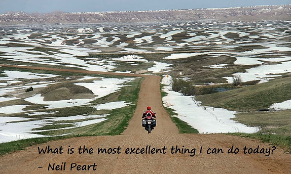
With that, we hope the Ghost Rider "Ride-along" (NEP's words, accompanied by Google Street View screenshots) inspires you to do your own MOST EXCELLANT THING!
<< The Ghost Rider "Ride-along>>
Ghost Rider "Ride-along" [Chapter 1 through Chapter 3 - linked] (map is also linked)
.jpg)